Oklahoma City Open Data
Licensing
Parks Impact Fees - Existing Local Service
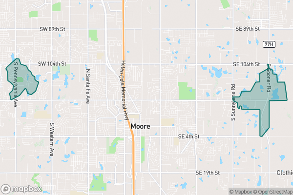
This dataset tracks areas in Oklahoma City that are exempt from paying park development fees
Source city: Oklahoma City · Catalog date: June 9, 2026 · License: custom
What this is
This dataset tracks areas in Oklahoma City that are exempt from paying park development fees.
Why it matters to you
If you’re developing property or building in Oklahoma City, these exemptions could save you money. The data helps determine whether your project falls in an area where park impact fees don’t apply—affecting your construction budget and planning. Developers, small businesses expanding their lots, or homeowners adding structures all need to check this before finalizing plans.
How to read this data
- Park Served: A number used to calculate whether fees apply to your location.
- Calculator: A code that helps determine fee exemptions (like a category label).
- Area: The size of the exempt zone in square feet—bigger areas mean more potential development sites are covered.
Where this leaves you
While this data doesn’t let you look up exemptions by address directly, it shows where fee-free zones exist. For specific projects, you’d need to cross-reference this map with your site’s location (or consult city planning staff). More details on fees are at okc.gov.
(Word count: 180)
The fields, explained
Pulled directly from the source catalog's published field definitions — not paraphrased.
| Field | What it means |
|---|
ObjectID | Numeric unique identifier with no special meaning |
Park Served | number used in fee calculation |
Calculator | enumeration used in fee calculation |
Shape | Geographic data in state plane coordinates (WKID 103512) |
Length | Approximate length of perimeter of feature in US feet |
Area | Approximate area of feature in US square feet |
From the source — real records
Unedited rows from Oklahoma City's published service, pulled when this site was built.
Look it up yourself
Everything on this page comes from the city's public open-data catalog. Anyone can download it — CSV, GeoJSON, KML, or the live service.
This explainer was written from the published catalog record. Always verify against the source dataset before relying on it for a decision.