Oklahoma City Open Data
Licensing
Streets Development Program - Benefit Areas
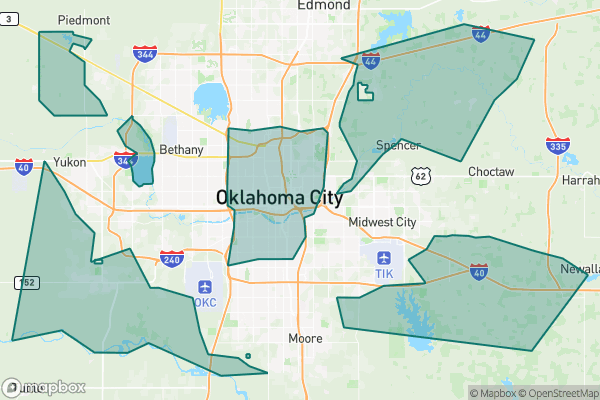
A dataset showing where street development projects are planned in the city
Source city: Oklahoma City · Catalog date: June 9, 2026 · License: custom
What this is
A dataset showing where street development projects are planned in the city.
Why it matters to you
This data helps you understand if your street or neighborhood will see construction, repaving, or other infrastructure work soon. Knowing this can affect when you schedule home repairs (to avoid overlapping with roadwork), where you choose to open a business (to avoid construction zones), or even which routes to take during your commute. Municipal budgets prioritize certain areas over others—this shows where those dollars are going.
How to read this data
Since no field descriptions are available, look for:
- Location boundaries: Likely shows streets or zones marked for development
- Project types: May include repaving, utility work, or sidewalk upgrades
- Timelines: If present, would show estimated start/end dates
Where this leaves you
Without address-specific details, you can’t look up your exact block, but this dataset still reveals which general areas will see changes. Check the raw data or city announcements for project lists by neighborhood.
The fields, explained
Pulled directly from the source catalog's published field definitions — not paraphrased.
| Field | What it means |
|---|
ObjectID | Numeric unique identifier with no special meaning |
Benefit Area | Classification of benefit area |
Category | Type of benefit area |
Calculator | Enumeration used in fee calculation |
Shape | Geographic data in state plane coordinates (WKID 103512) |
Length | Approximate length of perimeter of feature in US feet |
Area | Approximate area of feature in US square feet |
From the source — real records
Unedited rows from Oklahoma City's published service, pulled when this site was built.
Look it up yourself
Everything on this page comes from the city's public open-data catalog. Anyone can download it — CSV, GeoJSON, KML, or the live service.
This explainer was written from the published catalog record. Always verify against the source dataset before relying on it for a decision.