Oklahoma City Open Data
Transportation
Work Zones
This dataset tracks active construction and repair work zones across Oklahoma City streets, including lane, road, and sidewalk closures
Source city: Oklahoma City · Catalog date: June 10, 2026 · License: custom
What this is
This dataset tracks active construction and repair work zones across Oklahoma City streets, including lane, road, and sidewalk closures.
Why it matters to you
Work zones directly impact your daily commutes, business deliveries, and street accessibility. Knowing where and when lanes are closed helps you:
- Reroute to avoid delays when driving to work
- Check if sidewalk closures affect foot traffic to your storefront
- Plan alternate routes for trash pickup or moving trucks
How to read this data
Key fields to check:
- Work Type: What’s being done (e.g., “utility repair,” “resurfacing”)
- Start/End Date: When disruptions are expected (compare these to your schedule)
- Road/Lane Closure: “Yes” means full or partial roadblocks (check North/South/East/West Bound for lane-specific impacts)
- Sidewalk Closure: Critical for pedestrians and businesses with foot traffic
Try it yourself
Search the dataset for your street or neighborhood. If you see active work zones:
- Note the end date to anticipate delays
- Check if closures affect your usual routes to school, work, or deliveries
- Report errors (like outdated end dates) to the city’s public works department
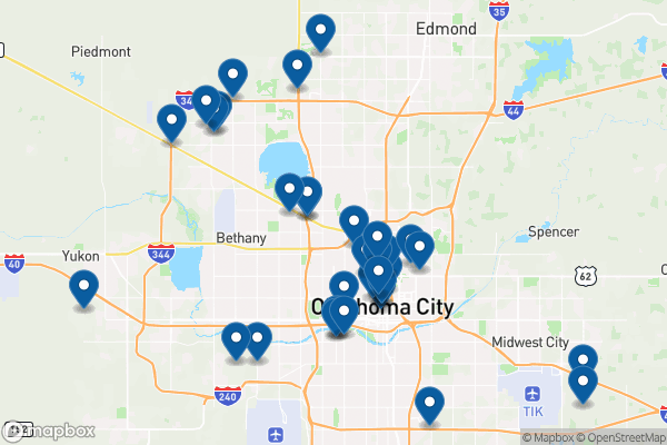
See it on a map
Markers at the dataset's published locations — click one for the record's details.
The fields, explained
Pulled directly from the source catalog's published field definitions — not paraphrased.
| Field | What it means |
|---|
ObjectID | Numeric unique identifier with no special meaning |
Work Type | Type of work being performed |
Start Date | Work start date based on issued permit |
End Date | Work end date based on issued permit |
Location | Location where work is being performed |
Work Zone Number | Alphanumeric number associated with work zone |
North Bound | indicates number of north bound lanes closed (if lane closure) |
South Bound | indicates number of south bound lanes closed (if lane closure) |
East Bound | indicates number of east bound lanes closed (if lane closure) |
West Bound | indicates number of west bound lanes closed (if lane closure) |
Road Closure | Indicates if the entire road will be closed |
Lane Closure | Indicates if lanes will be closed |
Sidewalk Closure | Indicates if sidewalks will be closed. Right-of-way |
Work | Indicates if work is being performed in the right-of-way |
Shape | Geographic data in state plane coordinates (WKID 103512) |
From the source — real records
Unedited rows from Oklahoma City's published service, pulled when this site was built.
Look it up yourself
Everything on this page comes from the city's public open-data catalog. Anyone can download it — CSV, GeoJSON, KML, or the live service.
This explainer was written from the published catalog record. Always verify against the source dataset before relying on it for a decision.